Scan to BIM Explained: From Point Cloud to Intelligent Revit Model
As the Architecture, Engineering, and Construction (AEC) industry continues embracing digital transformation, the demand for accurate building information has never been greater. Many renovation, retrofit, facility management, and infrastructure projects require precise information about existing conditions before design or construction work begins.
Traditionally, site measurements were collected manually using tapes, total stations, and field surveys. While effective, these methods were often time-consuming and vulnerable to human error. Today, reality capture technologies have revolutionized the way existing buildings are documented through a process known as Scan to BIM.
Scan to BIM combines laser scanning technology with Building Information Modeling (BIM) to create accurate digital representations of physical structures. This workflow helps project teams improve design accuracy, reduce site visits, and make better decisions throughout the project lifecycle.
What is Scan to BIM?
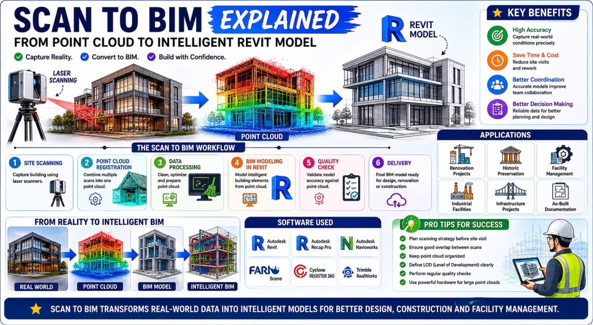
Scan to BIM is the process of capturing existing building conditions using laser scanning or reality capture technology and converting the collected data into an intelligent BIM model.
The process begins by scanning a building, facility, or site using laser scanners that generate millions of measurement points. These points create a highly detailed digital representation known as a Point Cloud.
The Point Cloud is then imported into BIM software such as Autodesk Revit, where BIM professionals use it as a reference to create walls, floors, roofs, structural elements, MEP systems, and other building components.
The result is an intelligent BIM model that accurately reflects existing site conditions.
Understanding Point Clouds
A Point Cloud is the foundation of every Scan to BIM workflow. It consists of millions or even billions of individual points captured by laser scanning equipment.
Each point contains precise spatial coordinates that represent the location of physical objects within the scanned environment. Together, these points form a detailed three-dimensional representation of buildings, structures, equipment, and surrounding environments.
Point Clouds provide extremely accurate measurements that help BIM modelers recreate existing conditions with a high level of confidence.
How Laser Scanning Works
Laser scanners emit laser beams that strike surfaces and return to the scanner. By measuring the time required for the laser to return, the scanner calculates precise distances to objects.
Modern scanners capture millions of points per second, allowing large buildings and facilities to be documented quickly and accurately.
Multiple scans are typically performed from different locations throughout a project site. These scans are later combined to create a complete Point Cloud dataset.
The Scan to BIM Workflow
Although workflows may vary depending on project requirements, most Scan to BIM projects follow a similar process.
1. Site Scanning
The first step involves capturing existing conditions using terrestrial laser scanners, mobile scanners, drones, or other reality capture technologies.
2. Point Cloud Registration
Individual scans are aligned and combined into a single coordinated Point Cloud dataset.
3. Data Processing
The Point Cloud is cleaned, optimized, and prepared for BIM modeling.
4. BIM Modeling
BIM specialists use software such as Revit to create intelligent building elements based on the Point Cloud data.
5. Quality Control
The BIM model is reviewed and validated against the Point Cloud to ensure accuracy.
6. Project Delivery
The completed BIM model is delivered for design, renovation, facility management, or construction purposes.
Benefits of Scan to BIM
Scan to BIM provides numerous advantages compared to traditional surveying and documentation methods.
- Highly accurate building documentation
- Reduced site visits
- Faster data collection
- Improved design confidence
- Better project coordination
- Reduced construction risks
- Enhanced renovation planning
- Improved facility management
These benefits make Scan to BIM an increasingly valuable workflow across the AEC industry.
Applications of Scan to BIM
Scan to BIM is used across a wide range of project types and industries.
Renovation Projects
Existing buildings often contain undocumented modifications and outdated drawings. Scan to BIM provides accurate existing condition models that support renovation design.
Historic Preservation
Historic structures require precise documentation before restoration work begins. Laser scanning captures intricate architectural details without physically disturbing the building.
Facility Management
Facility owners use Scan to BIM models to manage assets, plan maintenance activities, and support operational decision-making.
Industrial Facilities
Manufacturing plants, refineries, and industrial facilities often contain complex equipment layouts that benefit from accurate digital documentation.
Infrastructure Projects
Bridges, tunnels, transportation systems, and utility networks can also be documented using Scan to BIM workflows.
Software Used in Scan to BIM
Several software platforms support Scan to BIM workflows.
- Autodesk Revit
- Autodesk Recap Pro
- Navisworks
- Cyclone REGISTER 360
- FARO Scene
- Trimble RealWorks
- CloudCompare
Among these tools, Autodesk Revit remains one of the most commonly used platforms for creating BIM models from Point Cloud data.
Challenges in Scan to BIM Projects
Although Scan to BIM offers significant benefits, it also presents several challenges.
Large Point Cloud files can require powerful computer hardware and substantial storage capacity. Processing and managing these datasets may become complex for large facilities.
Another challenge involves determining the appropriate Level of Development (LOD) for BIM deliverables. Excessive modeling detail can increase project costs without providing additional value.
Project teams must also establish clear modeling standards and quality control procedures to maintain consistency.
Level of Development (LOD) in Scan to BIM
Not every Scan to BIM project requires the same level of detail. Project requirements often determine the appropriate LOD.
For example, a conceptual renovation project may only require basic building geometry, while facility management applications may require highly detailed asset information.
Clearly defining LOD requirements at the beginning of a project helps control costs and ensures that deliverables meet client expectations.
Scan to BIM and Digital Twins
The growth of Digital Twin technology is creating new opportunities for Scan to BIM workflows.
Digital Twins combine BIM models with real-time operational data from sensors and building systems. Accurate existing condition models generated through Scan to BIM often serve as the foundation for Digital Twin development.
As smart buildings and connected infrastructure become more common, Scan to BIM will play an increasingly important role in creating and maintaining digital representations of physical assets.
The Future of Scan to BIM
Advancements in laser scanning technology, artificial intelligence, machine learning, and cloud computing continue to improve Scan to BIM workflows.
AI-powered tools are beginning to automate portions of the modeling process by recognizing walls, doors, windows, pipes, and structural components directly from Point Cloud data.
These innovations will reduce modeling time, improve efficiency, and make reality capture workflows more accessible across the industry.
Conclusion
Scan to BIM has become an essential technology for capturing existing conditions and creating accurate digital building models. By combining laser scanning with BIM software, project teams can improve design accuracy, reduce project risks, and support better decision-making throughout the building lifecycle.
From renovation projects and facility management to infrastructure development and Digital Twins, Scan to BIM continues to transform how buildings and assets are documented and managed.
As reality capture technologies continue evolving, Scan to BIM will remain a critical workflow for architects, engineers, contractors, BIM managers, and facility owners seeking accurate and reliable building information.