What Are Shared Coordinates in Revit? A Complete Guide for BIM Coordination
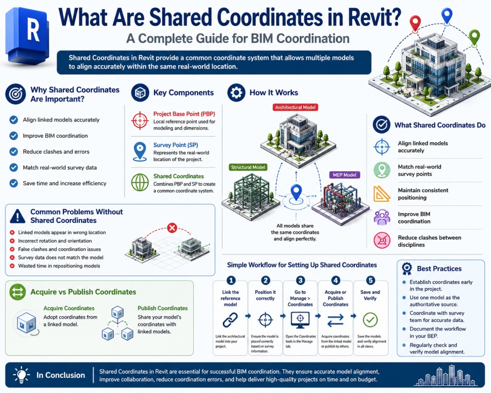
What Are Shared Coordinates in Revit?
Shared Coordinates in Revit are a coordinate management system that allows multiple Revit models to share a common reference point and orientation. In Building Information Modeling (BIM) projects, architects, structural engineers, and MEP engineers often work in separate Revit files. Without a shared coordinate system, these models may not align correctly when linked together. Shared Coordinates solve this problem by ensuring all project files use the same positioning information.
In modern construction projects, accurate model alignment is critical for successful collaboration. Shared Coordinates in Revit provide a consistent framework that allows different disciplines to work independently while maintaining proper coordination. Whether the project is a residential building, commercial tower, hospital, airport, or industrial facility, Shared Coordinates play an essential role in BIM workflows.
Why Shared Coordinates in Revit Are Important
One of the biggest challenges in BIM projects is coordinating multiple disciplines. Architectural, structural, and MEP teams often create separate models that need to fit together perfectly. If coordinate systems are inconsistent, linked models may appear in the wrong location, causing confusion and coordination issues.
Shared Coordinates in Revit help eliminate these problems by providing a common reference system. When all models use the same coordinates, teams can exchange files confidently knowing that everything will align correctly.
Proper implementation of Revit Shared Coordinates improves communication between project stakeholders, reduces coordination errors, and increases overall project efficiency. It also minimizes the time spent manually moving or rotating linked models during project updates.
Project Base Point and Survey Point Explained
To understand Shared Coordinates in Revit, it is important to understand two key reference points: the Project Base Point and the Survey Point.
Project Base Point (PBP) serves as the local reference point for the building model. It is typically used for internal measurements, dimensions, and modeling activities. Most designers work relative to the Project Base Point during daily project development.
Survey Point (SP) represents the actual geographic location of the project. Surveyors provide coordinate data that can be linked to the Revit model through the Survey Point. This ensures that the building is positioned accurately relative to the real world.
The combination of the Project Base Point and Survey Point creates the foundation of Shared Coordinates in Revit. Together, they allow multiple models to share the same coordinate system and maintain accurate positioning.
Benefits of Using Shared Coordinates in Revit
There are many advantages to implementing Shared Coordinates in Revit within BIM projects.
Improved BIM Coordination: All disciplines work using the same reference system, reducing alignment issues and improving collaboration.
Accurate Model Alignment: Architectural, structural, and MEP models automatically align when linked together.
Reduced Clash Detection Errors: Properly aligned models improve clash detection results in software such as Navisworks and Autodesk Construction Cloud.
Real-World Positioning: Models can be accurately positioned according to survey data and site conditions.
Increased Efficiency: Teams spend less time fixing coordinate issues and more time focusing on design and coordination.
Better Project Delivery: Accurate model positioning supports smoother workflows throughout design, construction, and facility management.
How Shared Coordinates Work in BIM Projects
Consider a project involving an architect, structural engineer, and MEP consultant. The architect creates the primary building model and establishes the project location. The structural and MEP teams then link the architectural model into their own files.
Using Acquire Coordinates, the structural and MEP models adopt the same coordinate system as the architectural model. As a result, all linked models align correctly without requiring manual adjustments.
Whenever updated models are exchanged, Revit uses the shared coordinate system to maintain consistent positioning. This process greatly improves BIM coordination and reduces the risk of errors.
How to Set Up Shared Coordinates in Revit
Setting up Shared Coordinates in Revit is a relatively simple process.
Step 1: Link the architectural model into the structural or MEP model.
Step 2: Verify that the linked model is positioned correctly according to project requirements and survey information.
Step 3: Open the Manage tab and locate the Coordinates panel.
Step 4: Use the Acquire Coordinates command to adopt coordinate information from the linked model.
Step 5: Save the project and verify alignment between all linked files.
Following these steps ensures that all project models use the same coordinate framework.
Acquire Coordinates vs Publish Coordinates
Two important tools used when working with Shared Coordinates in Revit are Acquire Coordinates and Publish Coordinates.
Acquire Coordinates allows a model to adopt coordinate information from another linked model. This is the most commonly used method in BIM projects because structural and MEP teams often acquire coordinates from the architectural model.
Publish Coordinates works in the opposite direction. It allows coordinate information from the current model to be transferred to linked models. This method is useful when the active model contains the correct coordinate data.
Understanding when to use Acquire Coordinates and Publish Coordinates is essential for maintaining accurate project alignment.
Common Problems Without Shared Coordinates
Projects that do not use Shared Coordinates in Revit often experience coordination challenges.
Linked models may appear hundreds of meters away from the project location.
Buildings may rotate unexpectedly when linked into another model.
Clash detection results may contain false conflicts due to incorrect positioning.
Survey information may not match the model location.
Teams may waste valuable time manually repositioning models after each update.
These issues can lead to delays, increased costs, and reduced project quality.
Best Practices for BIM Coordination
To achieve the best results with Shared Coordinates in Revit, establish coordinates early in the project and communicate the workflow to all consultants.
Use a single authoritative model as the coordinate source. In most projects, the architectural model serves this purpose.
Avoid manually moving linked models after coordinates have been established.
Regularly verify model alignment and coordinate settings throughout the project lifecycle.
Document coordinate procedures within your BIM Execution Plan (BEP) to ensure consistency across all disciplines.
Coordinate closely with surveyors to ensure that project location information remains accurate.
Conclusion
Shared Coordinates in Revit are a critical component of successful BIM coordination. They provide a common positioning system that allows architectural, structural, and MEP models to align accurately within the same real-world location.
By understanding the relationship between the Project Base Point, Survey Point, Acquire Coordinates, and Publish Coordinates, project teams can improve collaboration, reduce coordination errors, enhance clash detection, and create more reliable BIM models.
Whether you are a BIM Coordinator, Architect, Structural Engineer, MEP Engineer, or Revit professional, mastering Shared Coordinates in Revit is essential for delivering high-quality and coordinated BIM projects.